Longitude
4.15 - Understand the difference in local time for observers at different longitudes4.20 - Understand the principles of astronomical methods for the determination of longitude, including the lunar distance method
4.21 - Understand the principle of the horological method for the determination of longitude (Harrison’s marine chronometer) (knowledge of internal working of chronometers not required)
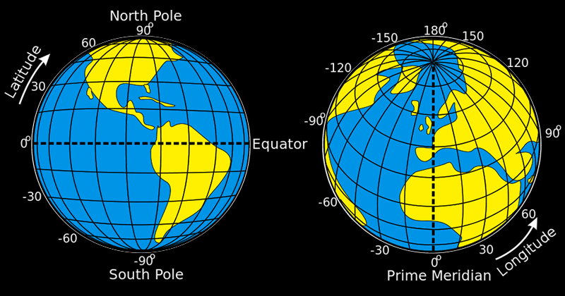
Latitude, knowing how far north or south you are, is straightforward enough to understand. The equator and poles are constants that we can measure from. Measuring longitude, knowing how far east or west you are, is more complex, because we don’t have a set position on the Earth to understand what is west or east.
We know that the Sun is at the highest part of the sky at local noon (with minor variations due to the equation of time). If you move 1 degree of longitude either way the Sun will culminate at midday, but your midday will be 4 minutes earlier or later than your previous location.
Accurate methods of determining longitude became more important as western civilisation relied more on naval transport for trade. A navigator can broadly track their position over distance by using 'dead reckoning' so they roughly know their speed and course and direction. The method was crude and taking these measurements at sea was an imperfect art. The result could mean ships crashing at sea, losing lives and merchandise.
A number of methods were suggested in the 18th century to find a solution to determining longitude. Astronomical methods were effective but not always reliable due to the complexity of taking observations and not having accurate data to compare it to. For example, observing the moons of Jupiter, plotting their position and comparing to a table of data was proved impractical at sea. A popular method involved the lunar distance method. Ultimately it was a non-astronomical method – an accurate clock – that solved the issue. Remember GPS has only been in existence since the latter part of the 20th century.
Lunar Distance Method
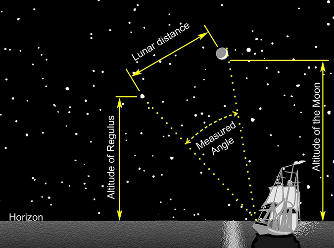
This method was used prior to the introduction of the chronometer. It involves calculating the distance between the moon and a prominent star to find the navigator's longitude.
The Moon moves across the sky at 13° over 24 hours (0.5° an hour). A navigator would measure the altitude of a prominent star above the horizon. Then they would observe the angle between the moon and the star. They would consult an almanac containing tables of data based on Greenwich and work out their longitude using the difference.
This method has some flaws. Noticeably it depends on a clear sky and accurate measurements being taken at sea. Early tables had a larger margin of error than later versions, so a fraction of a degree could result in the navigator being several nautical miles away from their destination. The Earth is not uniformly spherical which adds to the error.
Horological method
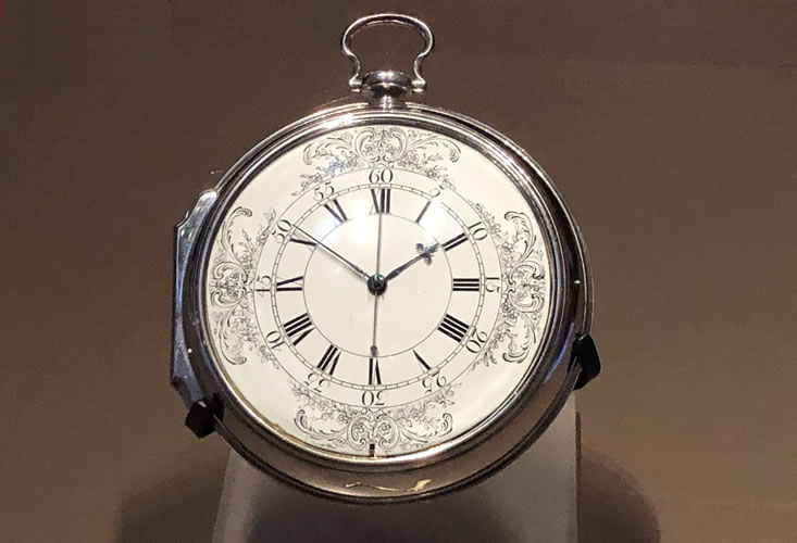
Horology is the study of time and to say someone is a horologist means they make clocks, watches and other timekeeping devices. John Harrison was a noted clockmaker in the 18th century who recognised the problem with using pendulum clocks on ships (ships movement effects the pendulum). He improved the technology and made innovations, some of which are still used in timekeeping devices today. His ‘H4’ – the ‘Sea Watch’ was the most accurate clock used for maritime use in its day.
At the time there was a ‘Board of Longitude’ set up by the government to arrive at an accurate time or method to solve the issue. The story is an interesting one which is worth researching. Subsequent and more affordable timekeepers that built on Harrison’s work ensured the horological method was more successful.
Navigators could now tell the local time at Greenwich and easily calculate the difference between their local time. They no longer needed to take complex observations or rely on good weather to do so. 'Dead reckoning' became more accurate and navigation safer.
Describing Latitude and Longitude
Latitude is measured from 0° at the equator to +90° at the north pole to -90° at the south pole. For example London is 51° N (north of the equator), Rio de Janeiro is 22° S (south of the equator).
Longitude is measured from 0° from the prime meridian to 180° east to 180° west. For example New York is 74°W (west of the prime meridian), Tokyo is 139°E (east of the prime meridian).
Summary
- Longitude = the measurement east or west of the prime meridian
- 4 minutes = 1 degree of longitude, 1 hour = 15° of longitude
See Also
Shadow Stick for determining longitude
Links
- The Greenwich Meridian Longitude
- National Geographic Longitude


 | © All Rights Reserved |