Latitude & Longitude
1.4 - Be able to use the latitude and longitude co-ordinate systemLatitude is how far north or south a position is.
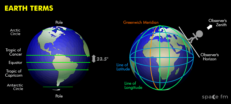
Longitude is how far west or east a position is.
Latitude
Latitude is a co-ordinate on the Earth's surface that measures how far north or south a position is.
It is a co-ordinate measured from 0° at the Equator to +90° at the North Pole or -90° at the South Pole. Sometimes these are shown as 90N or 90S.
The Equator and Tropics are lines of latitude.
An observer in the northern hemisphere can find their latitude by the angle to the Northern Celestial Pole (NCP) marked by the star Polaris.
Altitude of NCP = Latitude of Observer
Longitude
0° is the line of longitude that intersects the poles with the Greenwich Prime Meridian.
We measure the longitude co-ordinate up to 180° west or east of Greenwich.
On the opposite side of the world from the Greenwich Meridian is another line of longitude is called the International Dateline.
Animation
Earth Map 360°
Mix & Match
Did you know?
Earth travels through space at 100,000 kilometres per hour
Links
- Fourmilab See the Earth from any longitude, latitude and altitude
- LatLong.net Look-up Latitude and Longitude
 | © All Rights Reserved |